
August 10, 2020 – Flash flooding at West 24th Street and Cedar Shore Drive, just west of Cedar Lake with water nearly three feet deep. This was due to three inches of rain overnight. Read Here.
July 5, 2020 – Flash flooding at Maryland Avenue and White Bear Avenue in St. Paul due to a slow moving summer rain storm. Read Here.
August 13, 2019 – Flash flooding at West Broadway Ave. and West River Road. Read Here.
July 16, 2019 – Flash flooding (in Minneapolis) at the intersection of 26th Ave. S. & 25th St. E.; Dunwoody Blvd. near Lyndale Avenue South; 24th St. E. & Lyndale Ave. S.; I-35W, just south of downtown in the southbound lanes; and in Uptown along Bde Maka Ska. The city received approximately two inches of rain in one hour. Read Here.
July 23-24, 1987 – Flash flooding from the Twin Cities Superstorm in many low-lying areas; 9.15 inches of rain.
April 16, 1965 – Spring flooding along the Minnesota and Mississippi Rivers reached record levels. Interstate 35W was sandbagged in Burnsville but eventual overtopping closed the entire freeway. See Photo. “The Mississippi River crested at St. Paul at 26.01 feet.” There was flooding along Kellogg Blvd in downtown St. Paul. Read Here.
Photos

Kellogg Blvd in downtown St. Paul during the 1965 flood. (Photo Courtesy of the Minnesota Historical Society).
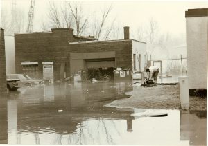
Spring flooding in the industrial area of the Bassett Creek Watershed of North Minneapolis. This is believed to be a now-razed area of Currie & Girard, near the former Import Engine Parts located at 1215 2nd Ave N. Man works to pump out a basement. (Photo by Twin Cities Almanac, circa 1990).
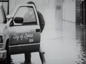
Bassett Creek flooding in springtime along Currie Ave. in Minneapolis in about 1990. An employee from the City of Lakes public works department was there to assess the situation. (Photo by Twin Cities Almanac).